For 24 Years, the Hurricane Forecast Map Stopped at the Coastline. In 2026, It Finally Went Inland.
NOAA just added inland watches and warnings to the hurricane forecast cone for the first time. Here's why that matters if you don't live on the coast.
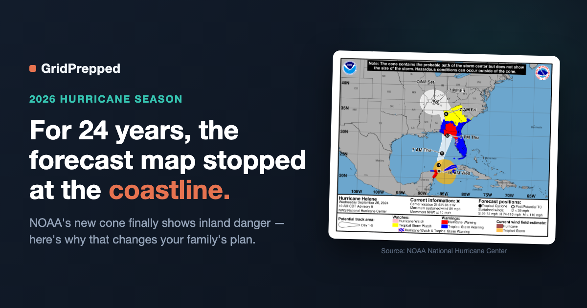
NOAA just rebuilt the hurricane forecast cone to include inland watches and warnings for the first time since the graphic debuted in 2002. The reason isn't subtle: the deadliest hurricane since Katrina did almost all its killing 300+ miles from the beach.
The cone used to end where the coast did
Since 2002, NHC's tropical cyclone forecast cone has shown one thing: where the storm's center is likely to track. Watches and warnings painted onto that map were coastal by default — hurricane and tropical storm alerts for the shoreline counties everyone assumes are "in the path."
That changed for 2026. Per NOAA's official release, the forecast cone now incorporates "all land-based (coastal and inland) tropical storm and hurricane watches and warnings in effect for the continental United States, Hawaii, Puerto Rico, and the U.S. Virgin Islands." NOAA ran this as an experiment in 2025 first, decided it worked, and made it the standard graphic starting this season.
Translate that out of agency-speak: for 23 years, if you lived two counties inland, the map you saw on the news simply wasn't built to warn you.
Helene is the reason this got fixed
Hurricane Helene made landfall in Florida in September 2024 as a Category 4 storm. The worst of it happened nowhere near the coast — it happened in the Southern Appalachians, in towns like Asheville, North Carolina, about 500 miles from where Helene came ashore.
NHC's final tropical cyclone report puts Helene's U.S. direct death toll at 176, making it the deadliest hurricane since Katrina. Of those direct deaths, at least 94 — the majority — were caused by freshwater flooding: 77 in North Carolina, 15 in Tennessee, 2 in South Carolina. This wasn't storm surge. It wasn't wind. It was rain falling on mountains hundreds of miles from any beach.
People there knew a hurricane was coming. What a lot of them didn't have was a mental model — or an alert system — that treated "hurricane" as a word that applied to them. As one Asheville resident later told a local outlet, after the mud and debris settled: "It sounds stupid to say this, but I didn't realize it would be like bombs going off." That's not a preparedness failure on his part. That's a communication gap NOAA is now, on its own admission, trying to close.
Warnings still only buy you 36 hours — coastal or not
Even with the improved cone, the underlying warning lead times haven't changed: NHC issues a hurricane warning 36 hours, and a hurricane watch 48 hours, before the anticipated onset of tropical-storm-force winds. That's the same math whether you're on the beach or on a ridge. Thirty-six hours sounds like a lot until you're using it to find flashlights, fill prescriptions, and figure out who's driving grandma somewhere safer — after you've already absorbed the news that it applies to you at all.
NOAA's own outlook for this season is a "below-normal" Atlantic year — 8 to 14 named storms, 3 to 6 hurricanes. NWS Director Ken Graham's response to that forecast is worth repeating exactly: "It only takes one storm to make for a very bad season." Helene happened in a year nobody was calling historically active, either.
How this plays out on GridPrepped
This is exactly why GridPrepped's risk profile and alert feed are built around your ZIP code, not your distance from a coastline. A hurricane watch or warning that now legitimately covers an inland county shows up in your feed the same way a coastal one does — because as of this year, NOAA agrees that's where it belongs. Enter your ZIP, and you see the hazards that are actually declared for your address, coastal or 500 miles inland.
None of this is a guarantee that an alert reaches you in time to matter, or that any tool prevents what a storm like Helene can do. It's one more layer between "I didn't think this applied to me" and knowing sooner. That gap is worth closing regardless of what NOAA's seasonal odds say.
Hard next step
If you live within a few hundred miles of the Gulf or Atlantic coast — including well inland — go set up alerts for your ZIP on GridPrepped before this season's peak, which historically runs mid-September through October. It's free, takes about a minute, and doesn't care whether you can see the ocean from your porch.
The map finally caught up to where the damage actually happens. Make sure your own plan has too.
Sources
- NOAA, "National Hurricane Center to issue new forecast cone graphics for 2026 hurricane season": https://www.noaa.gov/news-release/national-hurricane-center-to-issue-new-forecast-cone-graphics-for-2026-hurricane-season
- NOAA, "NOAA predicts below-normal 2026 Atlantic hurricane season": https://www.noaa.gov/news-release/noaa-predicts-below-normal-2026-atlantic-hurricane-season
- National Hurricane Center, NHC Issuance Criteria Changes for Tropical Cyclone Watches/Warnings: https://www.nhc.noaa.gov/watchwarn_changes.shtml
- National Hurricane Center, Tropical Cyclone Report, Hurricane Helene (AL092024): https://www.nhc.noaa.gov/data/tcr/AL092024_Helene.pdf
- NOAA Climate.gov, "Hurricane Helene's extreme rainfall and catastrophic inland flooding": https://www.climate.gov/news-features/event-tracker/hurricane-helenes-extreme-rainfall-and-catastrophic-inland-flooding
- The Assembly, "Hurricane Helene: A Disaster No One Saw Coming": https://www.theassemblync.com/essays/hurricane-helene-disaster-asheville/
Build your household's emergency plan
Free, and built around where you live.