A Magnitude 4.8 in New Jersey Was Felt in 33 States. A Bigger One in LA Was Felt in Five.
A M4.8 in New Jersey drew 184,672 USGS felt reports from 33 states. A M4.7 in LA drew 46,302 from five. What that means for your plan.
On April 5, 2024, a magnitude 4.8 earthquake hit Tewksbury, New Jersey. It broke no records for size. It did break one for reach: 184,672 people filed a "Did You Feel It?" report with the USGS — the most felt reports the agency has ever logged for a single earthquake, anywhere.
I pulled the ZIP-code-level response file for that event straight from the USGS product server and counted it out. Reports came in from 4,295 ZIP areas across 33 states and Washington, D.C. One came from Spring, Texas — 1,377 miles away.
Then I did the same thing for a nearly identical quake on the other side of the country, and the comparison is the whole point of this article.
Same magnitude, two completely different maps
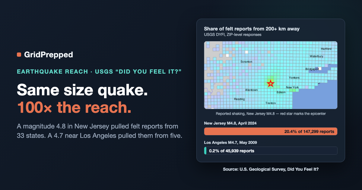
In May 2009, a magnitude 4.7 struck Lennox, California, just south of downtown Los Angeles. Same rough size, denser population nearby, same reporting system. Here's what the two response files look like side by side.
| Metric | New Jersey M4.8 (2024) | Los Angeles M4.7 (2009) |
|---|---|---|
| Total felt reports | 184,672 | 46,302 |
| ZIP areas reporting | 4,295 | 685 |
| States reporting | 33 + DC | 5 |
| Reports from 200+ km away | 20.4% | 0.2% |
| Reports from 300+ km away | 8.3% | 0.1% |
That last row is the one to sit with. One in five people who felt the New Jersey quake were more than 124 miles from it. In Los Angeles, that number was one in five hundred.
This isn't a quirk of two events. The USGS says it plainly in its own feature story, East vs West Coast Earthquakes: "Earthquakes east of the Rocky Mountains can cause noticeable ground shaking at much farther distances than comparably-sized earthquakes in the West." Their example is blunter than mine — the 2011 magnitude 5.8 in Mineral, Virginia was felt up to 600 miles out, while the 2014 magnitude 6.0 in Napa, California, which released roughly twice the energy, was felt only 250 miles out.
The mechanism is geology, not luck. Eastern North America sits on older, harder, denser rock, and its faults have had hundreds of millions of years to heal. Healed faults pass seismic energy along instead of absorbing it. Western rock is younger and cut up by fresher faults that soak the energy up close to the source.
There's a second detail in that USGS piece that matters more for houses than for skyscrapers: eastern quakes tend to produce higher-frequency shaking — faster back-and-forth motion — and shorter structures are more vulnerable to fast shaking. Your two-story house is a shorter structure.
Virginia, 2011: the part after the shaking
The Mineral, Virginia quake is the closest thing the East has to a modern case study, and I ran its numbers too: 131,070 felt reports from 8,603 ZIP areas in 36 states. Nearly 73% of those reports came from 200+ km away. The epicenter was 80 miles from Washington, D.C., and shaking there was amplified by the sediment under parts of the city — enough to damage the Washington Monument and the National Cathedral.
Now the slow part. I queried FEMA's OpenFEMA declarations database for what happened next. Virginia's major disaster declaration (DR-4042) came through on November 4, 2011 — 73 days after the August 23 incident date. The District's (DR-4044) took 77 days.
Two and a half months. That's not a scandal; earthquake damage assessments are genuinely slow, and federal aid was never designed to be your first 72 hours. But it's a useful number to hold in your head, because the same database explains why nobody in the East has practiced for any of this. Of 5,246 unique FEMA disaster declarations on record, exactly 36 are earthquakes — 0.69%. Fires account for 1,777. Severe storms, 1,136. And earthquake declarations have only ever touched 14 states and territories, most of them Pacific.
So east of the Rockies you get a hazard with enormous felt reach, older building stock, higher-frequency shaking, and essentially zero institutional muscle memory. That's the gap.
What to actually do with this
The takeaways here are unglamorous, which is usually a sign they're the right ones.
Assume the felt area is the crowd size. A quake big enough to rattle your windows will rattle windows in a dozen states at once. Everyone reaches for their phone in the same 90 seconds. Cell congestion is the predictable failure, not the exotic one — which is why a plan that names a single out-of-area contact and a text-first rule beats a plan that assumes calls connect.
Plan for shaking, not for magnitude. The number on the news describes the source. What matters at your address is distance, soil, and building age. If you're on sediment or in a pre-1970s structure, that's your risk profile regardless of what the magnitude was.
Do the ten-minute version. Secure the water heater. Move heavy things off high shelves above beds. Know where your gas shutoff is and what tool it takes. None of that requires believing an earthquake is coming.
Bridge the gap, don't wait for it. Seventy-three days to a federal declaration means your household plan is carrying the first stretch alone.
If you've never built a plan because earthquakes don't feel like your hazard, that's exactly the reasoning the FEMA numbers reward — right up until they don't. GridPrepped's plan builder walks your household through the boring, load-bearing parts: contacts, meeting points, shutoffs, and what everyone does in the first hour. And alerts is one way to hear about what's happening near you without refreshing five apps.
Building it once is easier than trying to think it up while the dishes are still moving.
Sources
- USGS "Did You Feel It?" ZIP-level response data, event us7000ma74 (2024 Tewksbury, New Jersey M4.8): https://earthquake.usgs.gov/earthquakes/eventpage/us7000ma74
- USGS DYFI data, event ci10410337 (2009 Lennox, California M4.7): https://earthquake.usgs.gov/earthquakes/eventpage/ci10410337
- USGS DYFI data, event se609212 (2011 Mineral, Virginia M5.8): https://earthquake.usgs.gov/earthquakes/eventpage/se609212
- USGS, "East vs West Coast Earthquakes": https://www.usgs.gov/news/featured-story/east-vs-west-coast-earthquakes
- OpenFEMA Disaster Declarations Summaries (declaration counts, dates, incident types): https://www.fema.gov/openfema-data-page/disaster-declarations-summaries-v2
Build your household's emergency plan
Free, and built around where you live.